

Atlas Program Images
Four Creeks Unincorporated Area Council
colLeft
Maps focused on a theme
Community and neighborhood maps
Community and neighborhood maps are the smallest mapped land areas. They're "palettes" for themes like "safety" (block watch and neighborhood emergency teams), "recreation" (parks and trails), "hydrology" (lakes, streams, etc.), and more.
Locally managed data can be included on the maps. A community often has visual features that are not generally available from public sources. The name of a development (e.g. Maple Hills Estates), a home-based business (e.g. Jill's Antiques), or a noticeable feature (the water tower) are examples of local data that can be "mapped".
Locally managed data can also be used to support community and neighborhood safety projects like block watch groups and neighborhood emergency teams.
High Valley Community
High Valley Community area
The High Valley Community is in the middle section of the Four Creeks May Valley subarea.
Click image to enlarge (PDF 300 dpi)

FCUAC_MayValley_Community_HighValley_area
(Right click or option-click the links and select "Save...As" to download the file)
PDF version of the map (300dpi)
PDF version of the map (700dpi)
High Valley Community area (roads)
The proposed boundaries of the High Valley Community are defined by a common road. This map removes the parcels to more clearly show the road and the streets it feeds.
The High Valley Community has only one road entrance/exit: 196th Ave SE which comes off of SE 128th St as it drops into May Valley.
As 196th Ave SE loops around the south end of Lake McDonald it becomes SE 150th St. The road becomes SE 152nd St, 207th Pl SE and 209th Ave SE before ending at SE 159th St.
The High Valley Community is initially defined by any parcels touched by this road network. Parcels can be added or removed at the discretion of the community.
NOTE: The High Valley Community may cover a larger area than the "High Valley" development (High Valley Home Owners Association)
Click image to enlarge (PDF 300 dpi)

FCUAC_MayValley_Community_HighValley_area_roads
(Right click or option-click the links and select "Save...As" to download the file)
PDF version of the map (300dpi)
PDF version of the map (700dpi)
High Valley Community
This particular map shows block watch and neighborhood emergency team information. The block watch areas are examples.
Block watch and neighborhood emergency teams are examples of locally maintained spatial data shown on a community or neighborhood map.
Click image to enlarge (PDF 300 dpi)

FCUAC_MayValley_Community_HighValley
(Right click or option-click the links and select "Save...As" to download the file)
PDF version of the map (300dpi)
PDF version of the map (700dpi)
Block Watch - Sample (High ValleyCommunity)
The High Valley Block Watch map provides information to a particular block watch neighborhood group.
Block watch and neighborhood emergency teams can create and map almost unlimited information to aid their efforts.
Click image to enlarge (PDF 300 dpi)

FCUAC_MayValley_Community_HighValley_BW
PENDING
(Right click or option-click the links and select "Save...As" to download the file)
PDF version of the map (300dpi)
PDF version of the map (700dpi)
Maple Hills Community
Maple Hills Community area
The Maple Hills Community is in the eastern section of the Four Creeks Plateau subarea.
Click image to enlarge (PDF 300 dpi)

FCUAC_Plateau_Community_MapleHills_area
(Right click or option-click the links and select "Save...As" to download the file)
PDF version of the map (300dpi)
PDF version of the map (700dpi)
Maple Hills Community area (roads)
The proposed boundaries of the Maple Hills Community are defined by a common road. This map removes the parcels to more clearly show the road and the streets it feeds.
The Maple Hills Community has only one road entrance/exit: 196th Ave SE which comes off of SE 128th St as it drops into May Valley.
As 196th Ave SE loops around the south end of Lake McDonald it becomes SE 150th St. The road becomes SE 152nd St, 207th Pl SE and 209th Ave SE before ending at SE 159th St.
The Maple Hills Community is defined by any parcels fed by this road network.
NOTE: The Maple Hills Community covers a larger area than the "Maple Hills" development (Maple Hills Maintenance Company)
Click image to enlarge (PDF 300 dpi)

FCUAC_Plateau_Community_MapleHills_area_roads
(Right click or option-click the links and select "Save...As" to download the file)
PDF version of the map (300dpi)
PDF version of the map (700dpi)
Maple Hills Community
This particular map shows block watch and neighborhood emergency team information. The Law/Smith-Barney block watch is real. The other areas are examples.
Block watch and neighborhood emergency teams are examples of locally maintained spatial data shown on a community or neighborhood map.
Click image to enlarge (PDF 300 dpi)

FCUAC_Plateau_Community_MapleHills
(Right click or option-click the links and select "Save...As" to download the file)
PDF version of the map (300dpi)
PDF version of the map (700dpi)
Block Watch - Law/Smith-Barney (Maple Hills Community)
The Law/Smith-Barney Neighborhood map provides information to that particular Maple Hills block watch group.
Block watch and neighborhood emergency teams can create and map almost unlimited information to aid their efforts.
Click image to enlarge (PDF 300 dpi)

FCUAC_Plateau_Community_MapleHills_BW_LS-B
(Right click or option-click the links and select "Save...As" to download the file)
PDF version of the map (300dpi)
PDF version of the map (700dpi)
Mirrormont Community
Mirrormont Community area
The Mirrormont Community is in the eastern section of the Four Creeks Issaquah Creek subarea.
Click image to enlarge (PDF 300 dpi)

FCUAC_IssaquahCreek_Community_Mirrormont_area
(Right click or option-click the links and select "Save...As" to download the file)
PDF version of the map (300dpi)
PDF version of the map (700dpi)
Mirrormont Community area (roads)
The proposed boundaries of the Mirrormont Community are defined by a common road. This map removes the parcels to more clearly show the road and the streets it feeds.
The High Valley Community has only one road entrance/exit: 196th Ave SE which comes off of SE 128th St as it drops into May Valley.
As 196th Ave SE loops around the south end of Lake McDonald it becomes SE 150th St. The road becomes SE 152nd St, 207th Pl SE and 209th Ave SE before ending at SE 159th St.
The High Valley Community is initially defined by any parcels touched by this road network. Parcels can be added or removed at the discretion of the community.
NOTE: The High Valley Community may cover a larger area than the "High Valley" development (High Valley Home Owners Association)
Click image to enlarge (PDF 300 dpi)

FCUAC_IssaquahCreek_Community_Mirrormont_area_roads
(Right click or option-click the links and select "Save...As" to download the file)
PDF version of the map (300dpi)
PDF version of the map (700dpi)
Mirrormont Community
This particular map shows block watch and neighborhood emergency team information. The block watch areas are examples.
Block watch and neighborhood emergency teams are examples of locally maintained spatial data shown on a community or neighborhood map.
Click image to enlarge (PDF 300 dpi)

FCUAC_IssaquahCreek_Community_Mirrormont
(Right click or option-click the links and select "Save...As" to download the file)
PDF version of the map (300dpi)
PDF version of the map (700dpi)
Block Watch - Sample (Mirrormont Community)
The Mirrormont Block Watch map provides information to a particular block watch neighborhood group.
Block watch and neighborhood emergency teams can create and map almost unlimited information to aid their efforts.
Click image to enlarge (PDF 300 dpi)

FCUAC_IssaquahCreek_Community_Mirrormont_BW
PENDING
(Right click or option-click the links and select "Save...As" to download the file)
PDF version of the map (300dpi)
PDF version of the map (700dpi)
Sunset Valley Farms Community
Sunset Valley Farms Community area
The Sunset Valley Farms Community is in the eastern section of the Four Creeks May Valley subarea.
Click image to enlarge (PDF 300 dpi)

FCUAC_MayValley_Community_SunsetValleyFarms_area
(Right click or option-click the links and select "Save...As" to download the file)
PDF version of the map (300dpi)
PDF version of the map (700dpi)
Sunset Valley Farms Community area (roads)
The proposed boundaries of the High Valley Community are defined by a common road. This map removes the parcels to more clearly show the road and the streets it feeds.
The High Valley Community has only one road entrance/exit: 196th Ave SE which comes off of SE 128th St as it drops into May Valley.
As 196th Ave SE loops around the south end of Lake McDonald it becomes SE 150th St. The road becomes SE 152nd St, 207th Pl SE and 209th Ave SE before ending at SE 159th St.
The High Valley Community is initially defined by any parcels touched by this road network. Parcels can be added or removed at the discretion of the community.
NOTE: The High Valley Community may cover a larger area than the "High Valley" development (High Valley Home Owners Association)
Click image to enlarge (PDF 300 dpi)

FCUAC_MayValley_Community_SunsetValleyFarms_area_roads
(Right click or option-click the links and select "Save...As" to download the file)
PDF version of the map (300dpi)
PDF version of the map (700dpi)
Sunset Valley Farms Community Block Watch and NET (sample)
This particular map shows block watch and neighborhood emergency team information. The block watch areas are examples.
Block watch and neighborhood emergency teams are examples of locally maintained spatial data shown on a community or neighborhood map.
Click image to enlarge (PDF 300 dpi)

FCUAC_MayValley_Community_SunsetValleyFarms
(Right click or option-click the links and select "Save...As" to download the file)
PDF version of the map (300dpi)
PDF version of the map (700dpi)
Block Watch - Sample (Sunset Valley Farms Community)
The Sunset Valley Farms Block Watch map provides information to a particular block watch neighborhood group.
Block watch and neighborhood emergency teams can create and map almost unlimited information to aid their efforts.
Click image to enlarge (PDF 300 dpi)

FCUAC_MayValley_Community_SunsetValleyFarms_BW
(Right click or option-click the links and select "Save...As" to download the file)
PDF version of the map (300dpi)
PDF version of the map (700dpi)
Eberle Block Watch
Eberle Block Watch
The Eberle Block Watch map provides information to a particular block watch neighborhood group.
Block watch and neighborhood emergency teams can create and map almost unlimited information to aid their efforts.
Click image to enlarge (PDF 300 dpi)

FCUAC_Plateau_Community_Eberle_BW
(Right click or option-click the links and select "Save...As" to download the file)
PDF version of the map (300dpi)
PDF version of the map (700dpi)
Project and Event maps
NOTE: This section not started; spaceholders only
- T291 Stewardship
- NOTE: This section not started; spaceholders only
Tributary 291 Stewardship Area (T291)
Recreation and Trails
A map showing the parks and trails in the T291 Stewardship area.

T291_Recreation_Area
(Right click or option-click the links and select "Save...As" to download the file)
PDF version of the map (300dpi)
PDF version of the map (700dpi)
T291_Recreation
T291_Hydrology_Area
T291_Hydrology
T291_Roads_Area
T291_Adopt-a-Road
Area maps
- King County
- Greater Four Creeks Area
- Subareas
- Sections
- Communities
- Neighborhood, project, or event
Greater Four Creeks Area
Recreation and Trails (Four Creeks area)
A map showing the parks and trails in the Greater Four Creeks unincorporated area.

FCUAC_Recreation
(Right click or option-click the links and select "Save...As" to download the file)
PDF version of the map (300dpi)
PDF version of the map (700dpi)
Recreation and Trails (King County)
A map showing the parks and trails in King County.

KC_Recreation
(Right click or option-click the links and select "Save...As" to download the file)
PDF version of the map (300dpi)
PDF version of the map (700dpi)
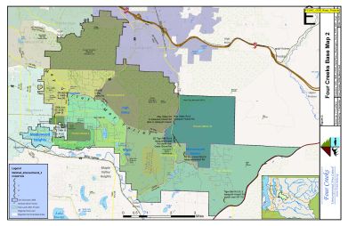
Greater Four Creeks Subareas
A map showing the Four Creeks subareas

FCUAC_Subareas
(Right click or option-click the links and select "Save...As" to download the file)
PDF version of the map (300dpi)
PDF version of the map (700dpi)
King County
King County Land Use
A map showing the King County Comprehensive Plan Land Use

KC_CompPlanLU
(Right click or option-click the links and select "Save...As" to download the file)
PDF version of the map (300dpi)
PDF version of the map (700dpi)
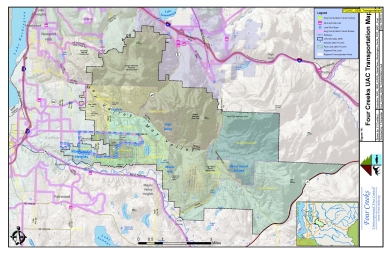
Four Creeks Transportation - Roads
A map showing the roads within the Four Creeks area

FCUAC_Transportation_Roads
(Right click or option-click the links and select "Save...As" to download the file)
PDF version of the map (300dpi)
PDF version of the map (700dpi)
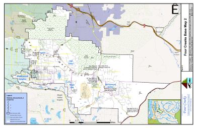
Four Creeks Hydrology
A map showing the hydrology in the Four Creeks area

FCUAC_Hydrology
(Right click or option-click the links and select "Save...As" to download the file)
PDF version of the map (300dpi)
PDF version of the map (700dpi)
Archives
A map of the metro routes
FCUAC_GDB_Transportation
A map showing the metro transportation routes and stops. Note that the UAC was shifted right in the window to allow for more of the metro routes to be shown. Need to move it back or produce a special "area" to include more of the surrounding places.
An overlay of road intersections, segments, etc.
FCUAC_GDB_Road_Projects
A map showing the location of some road intersections. This is based on a table used by FCUAC to communicate with KC DOT Roads.
An overlay of road intersections, segments, etc. with different base
FCUAC_GDB_Road_Projects2
Same as FCUAC_GDB_Road_Projects but with a different base.
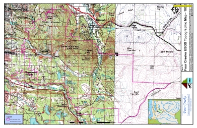
FCUAC_GDB_USGS_100k
USGS 100k sample. USGS maps also are included in the base section.

FCUAC_GDB_USGS_1x2
USGS 1x2 sample

FCUAC_GDB_Vegetation
UAC Area; forest cover
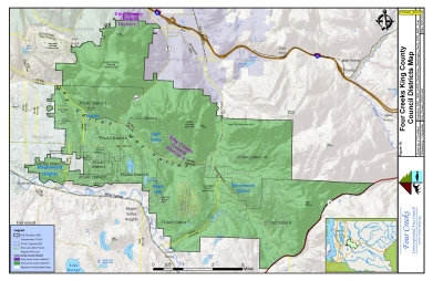
FCUAC_KCCD
King County Council Districts
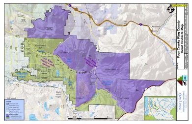
FCUAC_KingCo_Courts
King County Court Districts
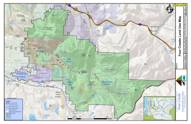
FCUAC_Land_Use
Land use from a FCUAC table. That table identifies Districts as all urban, all rural or mixed.
This is not a very useful piece of information and would be better displayed at the precinct level with the Urban Growth Boundary on the map.
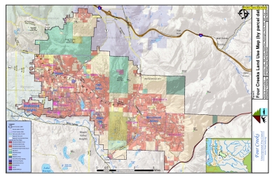
FCUAC_Land_Use-Parcel
Picks a number of land use designations and maps to the parcel. This map should be updated to use the King County Comprehensive Plan land use categories.
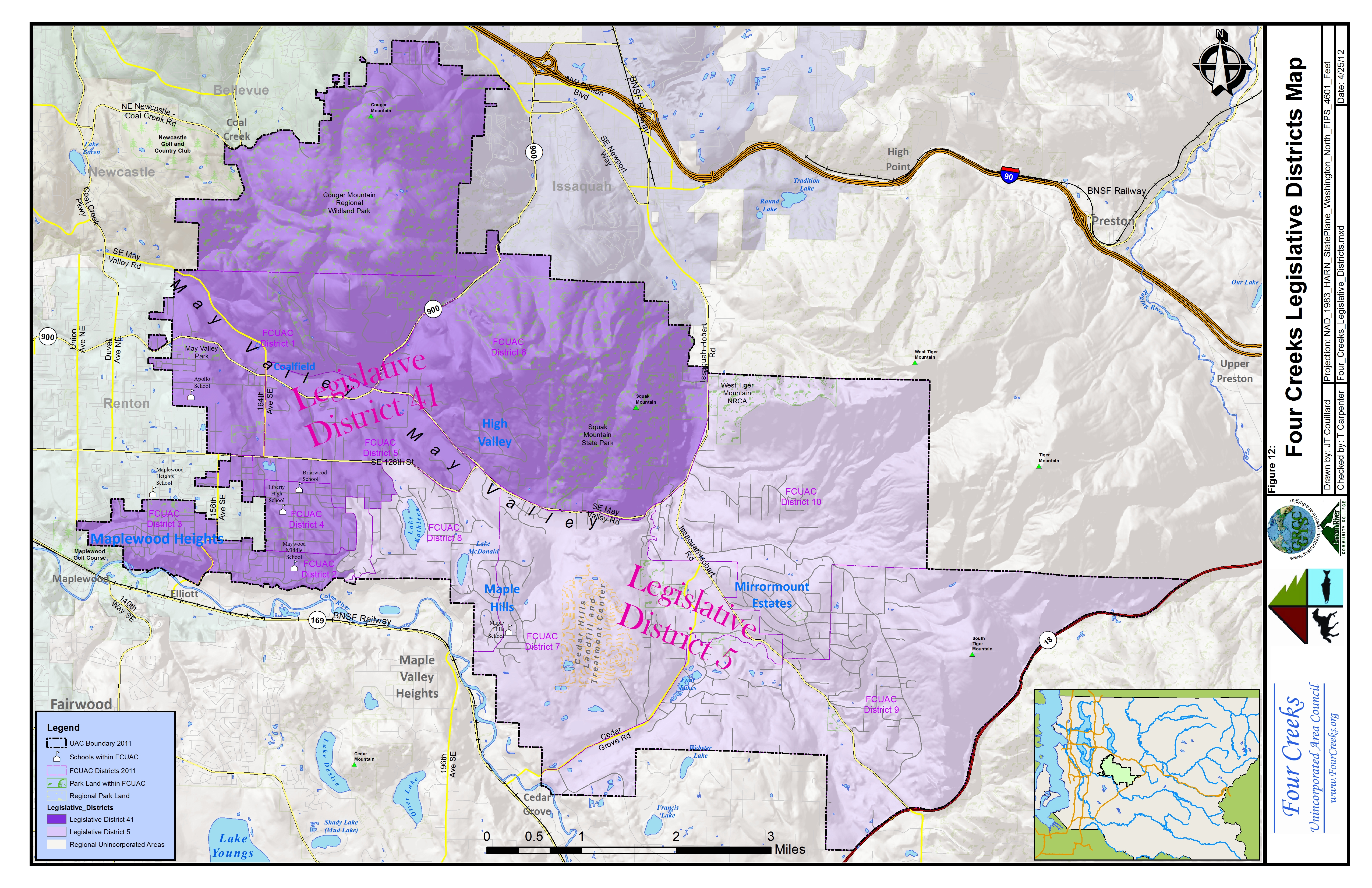
FCUAC_Legislative_Districts
Washington State legislative districts.
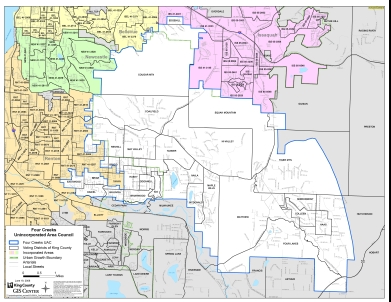
FCUAC_Precinct_2008-06-19
King County produced UAC precinct map. Used as a reference.

FCUAC_Test_GDB_Forest_Cover2
Forest cover

FCUAC_Test_GDB_LandUse1
????

FCUAC_Test_GDB_LandUse2
????

FCUAC_Test_GDB_LandUse3
????

FCUAC_Test_GDB_Parcels
????

FCUAC_Test_GDB_Subareas
?????

FCUAC_Test_GDB_Subareas_relief2
?????

FCUAC_Test_GDB_Transportation
????

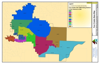
FCUAC_Test_GDB_Voting_Districts
FCUAC voting precincts

FCUAC_Test_GDB_Voting_Districts-5-1-10
????

FCUAC_Test_GDB_Voting_Districts-white
FCUAC voting districts
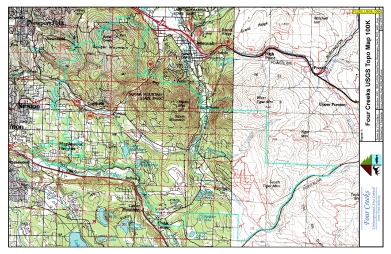
FCUAC_USGS_100K
USGS maps are included in themes and base.
FCUAC_Voting_Districts_11x17
FCUAC Districts
Things to remember
Content
- Atlas maps are always subject to update
- Individual maps may be relatively mature while others may be draft or sample maps
Layout
- The map logo contains the map title, projection, file name, and version date
- Maps are "drawn" on an 11-inch by 17-inch canvas with a 0.3-inch margin
Output
- PDF versions are included for each map.
- Print-quality PDF maps are displayed when thumbnail images are clicked
- PDF maps come in 300dpi and 700dpi versions
- 300dpi maps produce high-quality 11"x17" paper sizes or less
- 700dpi maps will produce high-quality maps up to 24" wide or 36" long
- NOTE: The GRCC logo is stored at 500dpi. There may be some loss of quality when maps larger that 20" wide are produced
- Most maps are designed for 11"x17" (landscape) or 17"x11" (portrait) output when printed
- If printed on smaller paper, make sure the output is properly oriented and that the output is set to "fit" to the paper's printable area.
Relevant documents
- In some cases there is a document included that is related to the theme map.
- These documents contain text and other information that helps explain the related theme map.